
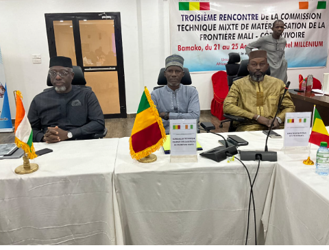
For communities living along the Côte d’Ivoire–Mali frontier, the border has long existed more on paper than in the physical landscape. That gap moved closer to closing in late August, when technical experts from both nations met in Bamako and reached a consensus on the exact path of the shared boundary.
The fourth session of the Joint Technical Commission for the Materialization of the Côte d’Ivoire–Mali Border, held from August 21 to 25, produced three concrete outcomes: a definitive border layout adopted by consensus, a validated draft delimitation treaty, and an agreed outline for the geodetic framework that will guide future demarcation work.
This progress did not emerge from maps alone. The decisions rest partly on a joint reconnaissance mission conducted from April 12 to 19 in the Pogo-Zégoua area, where technicians compared older cartographic records against on-the-ground conditions to settle the last remaining uncertainties along the roughly 532-kilometer border.
What Adoption Actually Means
The Bamako agreement is a technical adoption, not a final legal one. The draft delimitation treaty still requires signature by both governments before it gains full legal force. Beyond that, the geodetic base framework must be deployed before the end of 2026 to allow boundary marking to begin.
Understanding the distinction between delimitation and demarcation is essential here. Delimitation legally defines the border’s path on paper. Demarcation makes that line visible and enforceable on the ground through physical markers and coordinates recognized by both states. Between these two stages lie consultations, topographical surveys, funding arrangements, and an information campaign aimed at villages near the frontier.
Daily Stakes for Border Communities
For residents, the practical consequences of a poorly understood boundary are significant. An unclear line can complicate administrative authority, create uncertainty over agricultural land, disrupt tax collection, and fuel disputes between communities. The materialization process will therefore need to be paired with local outreach and accessible mechanisms for resolving grievances.
There is also the matter of preserving cross-border life. Families, herders, farmers, and traders in this region maintain relationships that often predate the existence of the two states. The goal of placing markers is to prevent conflict without turning the border into a barrier to lawful movement and commerce.
The Pogo-Zégoua crossing sits on one of the principal routes linking Bamako to Ivorian territory and its port infrastructure. Greater territorial clarity could improve coordination among Customs, Police, Gendarmerie, and local authorities. Still, clarity alone will not eliminate the corridor’s persistent issues with delays, harassment, or security risks.
Cooperation Beyond Cartography
The African Union frames delimitation and demarcation within a broader policy of dispute prevention and cross-border cooperation. Its Border Programme encourages states to pair cartographic work with joint projects, coordinated management of adjacent areas, and stronger local administrations.
This dimension carries particular weight for Mali and Côte d’Ivoire. The two countries had already agreed in 2021 to enhance intelligence sharing and conduct joint or simultaneous patrols along their shared border. The deteriorating security situation in parts of southern Mali and northern Côte d’Ivoire has since given that coordination added urgency.
The Bamako agreement provides a foundation, but its real value will be measured by what follows. The treaty’s signing, publication of essential documents, actual installation of markers, and genuine involvement of local populations will determine whether these commitments translate into visible change.
The next phase should not simply turn a map into a materialized line. It must make the border a better-administered, safer, and sufficiently open space to preserve the exchanges on which communities on both sides depend.
Experts from Mali and Côte d’Ivoire have agreed on the definitive layout of their shared border. This technical breakthrough still needs to be enshrined in a treaty and then materialized on the ground before it can have lasting effects.
Source: Journal du Mali

Comments